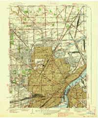
1938 Map of Toledo
USGS Topo · Published 1938About this map
Industrial expansion and rail infrastructure define the landscape along the Maumee River just before the second World War. The city is a major transportation hub, evidenced by the massive concentrations of rail activity at Air Line Junction, Lang Yard, and the Cloverleaf Yard. These yards support an intricate network including the Wheeling and Lake Erie RR and the Michigan Central RR. Beyond the heavy industry and central business district, which includes the Federal Building and Court House, the map reveals the residential and educational growth of the era through sites like Toledo University and several high schools such as De Vilbiss High Sch. North of the city, the Michigan-Ohio state line passes through rural tracts like Bedford and Washington, where smaller settlements like Wernert Corners and Alexis are visible before their later suburban consolidation.
Find a feature on this map
134 named features on this map. Tap any name to fly to it.
Don’t see what you’re looking for? This feature index may not catch every label — zoom into the map to look around manually.
Map Details
Editions of this 1938 Toledo Map
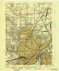
2 editions found
Other maps of this area

1900 · Maumee Bay
USGS Topo · 1:62,500

1900 · Toledo
USGS Topo · 1:62,500

1912 · Monroe
USGS Topo · 1:62,500

1912 · Dundee
USGS Topo · 1:62,500

1914 · Monroe
USGS Topo · 1:62,500

1926 · Dundee
USGS Topo · 1:62,500

1934 · Point Place
USGS Topo · 1:24,000

1934 · Rossford
USGS Topo · 1:24,000

1935 · Walbridge
USGS Topo · 1:24,000

1935 · Maumee
USGS Topo · 1:24,000