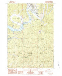
1984 Map of Toledo South
USGS Topo · Published 1984About this map
The Yaquina River dominates this mid-1980s survey, winding past the town of Toledo and the industrial infrastructure of the Southern Pacific railroad. The landscape is a complex network of tidewater sloughs, including Depot Slough, Olalla Slough, and Boone Slough, which frame the low-lying Boone Island. This area reflects a timber and transit economy, evidenced by the Toledo Airport and the strategic Butler Bridge. Further south, the terrain rises sharply into the Siuslaw National Forest, where the City of Toledo Watershed protects the headwaters of Mill Creek near Strawberry Mtn. Local landmarks like the Sunnyridge Grange and a Historical Monument at Craigie Point offer specific points of interest for genealogists tracing the social and physical history of Lincoln County's coastal interior.
Find a feature on this map
50 named features on this map. Tap any name to fly to it.
Don’t see what you’re looking for? This feature index may not catch every label — zoom into the map to look around manually.
Map Details
Editions of this 1984 Toledo South Map
This is the sole edition of this map. No revisions or reprints were ever made.
Other maps of this area

1922 · Waldport
USGS Topo · 1:62,500

1942 · Waldport
USGS Topo · 1:62,500

1942 · Yaquina
USGS Topo · 1:62,500

1942 · Tidewater
USGS Topo · 1:62,500

1942 · Toledo
USGS Topo · 1:62,500

1953 · Salem
USGS Topo · 1:250,000

1954 · Salem
USGS Topo · 1:250,000

1956 · Tidewater
USGS Topo · 1:62,500

1956 · Waldport
USGS Topo · 1:62,500

1957 · Yaquina
USGS Topo · 1:62,500