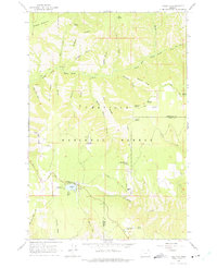
1963 Map of Tollgate
USGS Topo · Published 1975About this map
Umatilla National Forest dominates this mid-century high-country terrain, where the mountain landscape is defined by the headwaters of the South Fork Walla Walla River and Lookingglass Creek. Near the settlement of Tollgate, Langdon Lake and its Spillway serve as a focal point for the surrounding forest camps and recreational areas. The map reveals a network of fire management and forestry infrastructure, including the McIntyre Lookout and the Spout Springs Lookout Tower at the southern edge.
Find a feature on this map
57 named features on this map. Tap any name to fly to it.
Don’t see what you’re looking for? This feature index may not catch every label — zoom into the map to look around manually.
Map Details
Editions of this 1963 Tollgate Map
Other maps of this area

1953 · Pendleton
USGS Topo · 1:250,000

1955 · Grangeville
USGS Topo · 1:250,000

1956 · Pendleton
USGS Topo · 1:250,000

1959 · Grangeville
USGS Topo · 1:250,000

1963 · Big Meadows
USGS Topo · 1:24,000

1963 · Andies Prairie
USGS Topo · 1:24,000

1963 · Bingham Springs
USGS Topo · 1:24,000

1963 · Tollgate
USGS Topo · 1:24,000

1963 · Blalock Mountain
USGS Topo · 1:24,000

1963 · Peterson Ridge
USGS Topo · 1:24,000