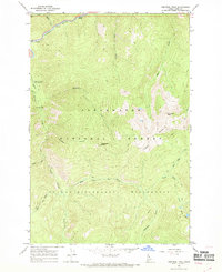
1966 Map of Tom Beal Peak
USGS Topo · Published 1969About this map
Jerry Johnson Hot Springs and the surrounding Idaho backcountry are documented here during a mid-1960s field survey. The area is defined by the sharp descent of the Lochsa River and its numerous tributaries, including Warm Springs Creek and Squaw Creek. This landscape represents a critical intersection of federal land management, where the Clearwater National Forest meets the Selway Bitterroot Wilderness.
Find a feature on this map
20 named features on this map. Tap any name to fly to it.
Don’t see what you’re looking for? This feature index may not catch every label — zoom into the map to look around manually.
Map Details
Editions of this 1966 Tom Beal Peak Map
2 editions found
Other maps of this area

1911 · Lolo
USGS Topo · 1:250,000

1913 · Lolo
USGS Topo · 1:250,000

1956 · Hamilton
USGS Topo · 1:250,000

1959 · Hamilton
USGS Topo · 1:250,000

1960 · Hamilton
USGS Topo · 1:250,000

1964 · Hamilton
USGS Topo · 1:250,000

1964 · Rocky Point
USGS Topo · 1:24,000

1966 · Mc Connell Mtn
USGS Topo · 1:24,000

1966 · Grave Peak
USGS Topo · 1:24,000
1966 · Hungry Rock
USGS Topo · 1:24,000