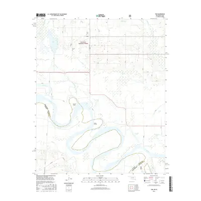
2016 Map of Tom
USGS Topo · Published 2016About this map
The Red River defines the landscape of this border region, carving a serpentine path through the alluvial bottomlands where the Oklahoma-Texas line meets. The river's dynamic nature is evident in the complex network of oxbows and sloughs, including the Bailey Cut-off and Billy Hall Bend. In the northern portion of the sheet, the southern reaches of the Ouachita National Forest provide a contrast to the water-dominated south, with the small community of Tom serving as a local hub. Genealogists and local historians will find significant value in the documentation of numerous family burial sites tucked away in the forest and near the settlement, such as Harris Cem, Byrms Cem, Manning Cem, and Pine Ridge Cem. The map illustrates the specialized water features of the Red River valley, from named marshes like Red Slough to secluded bodies like Churchhouse Lake and New Lake.
Find a feature on this map
36 named features on this map. Tap any name to fly to it.
Don’t see what you’re looking for? This feature index may not catch every label — zoom into the map to look around manually.
Map Details
Editions of this 2016 Tom Map
This is the sole edition of this map. No revisions or reprints were ever made.
Other maps of this area

1950 · De Kalb NW
USGS Topo · 1:24,000

1950 · Haworth
USGS Topo · 1:24,000

1950 · Tom
USGS Topo · 1:24,000

1950 · De Kalb
USGS Topo · 1:24,000

1950 · Oak Grove
USGS Topo · 1:24,000

1950 · Bokhoma
USGS Topo · 1:24,000

1951 · De Kalb
USGS Topo · 1:24,000

1951 · De Kalb NW
USGS Topo · 1:24,000

1951 · Haworth
USGS Topo · 1:24,000

1951 · Tom
USGS Topo · 1:24,000