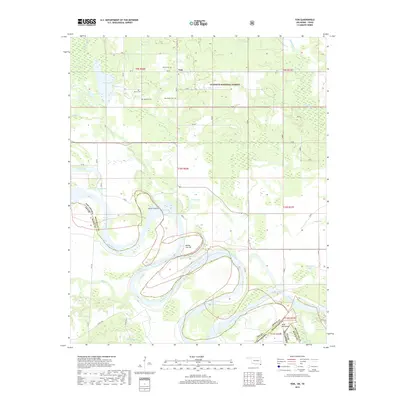
2019 Map of Tom
USGS Topo · Published 2019About this map
Tom sits in the northeastern corner of this landscape, a small community at the edge of the Ouachita National Forest. The geography is defined by the massive, winding course of the Red River, which forms the border between Oklahoma and Texas. The river's dynamic history is visible in its complex hydrology, featuring numerous oxbow lakes such as Caney Lake, Gunn Lake, and Churchhouse Lake, along with distinctive river features like Severn Island and the Bailey Cut-off. For those tracing local family history, several small burial sites are documented, including Harris Cem, Manning Cem, Byrms Cem, and Pine Ridge Cem. The transition from the forested uplands in the north to the low-lying bayous and sloughs of the river bottom, such as Red Slough and Hooks Bayou, illustrates the flood-prone nature of the McCurtain and Bowie County borderlands.
Find a feature on this map
40 named features on this map. Tap any name to fly to it.
Don’t see what you’re looking for? This feature index may not catch every label — zoom into the map to look around manually.
Map Details
Editions of this 2019 Tom Map
This is the sole edition of this map. No revisions or reprints were ever made.
Other maps of this area

1950 · De Kalb NW
USGS Topo · 1:24,000

1950 · Haworth
USGS Topo · 1:24,000

1950 · Tom
USGS Topo · 1:24,000

1950 · De Kalb
USGS Topo · 1:24,000

1950 · Oak Grove
USGS Topo · 1:24,000

1950 · Bokhoma
USGS Topo · 1:24,000

1951 · De Kalb
USGS Topo · 1:24,000

1951 · De Kalb NW
USGS Topo · 1:24,000

1951 · Haworth
USGS Topo · 1:24,000

1951 · Tom
USGS Topo · 1:24,000