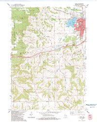
1983 Map of Tomah
USGS Topo · Published 1984About this map
The city of Tomah serves as the focal point for this survey, located at the junction of the Chicago Milwaukee St Paul and Pacific railroad and the waters of Lake Tomah. To the west, the rugged topography of the Fort McCoy Military Reservation dominates the landscape, featuring prominent elevations such as Bald Bluff and Windrow Bluff. This area illustrates a mid-century transition in rural Wisconsin, where traditional farming communities around the small settlements of Jacksonville and Ridgeville coexist with expanding military and transportation infrastructure.
Find a feature on this map
62 named features on this map. Tap any name to fly to it.
Don’t see what you’re looking for? This feature index may not catch every label — zoom into the map to look around manually.
Map Details
Editions of this 1983 Tomah Map
This is the sole edition of this map. No revisions or reprints were ever made.
Other maps of this area

1916 · Tomah
USGS Topo · 1:62,500

1919 · Kendall
USGS Topo · 1:62,500

1921 · Kendall
USGS Topo · 1:62,500

1947 · Millston
USGS Topo · 1:62,500

1949 · Millston
USGS Topo · 1:62,500

1949 · Tomah
USGS Topo · 1:62,500

1953 · Eau Claire
USGS Topo · 1:250,000

1958 · Eau Claire
USGS Topo · 1:250,000

1958 · Wyeville
USGS Topo · 1:48,000

1958 · La Crosse
USGS Topo · 1:250,000