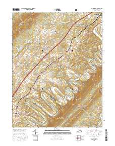
2016 Map of Toms Brook
USGS Topo · Published 2016About this map
The North Fork Shenandoah River carves a dramatic path through the Shenandoah Valley here, most notably at the series of sharp river meanders known as the Seven Bends. This 2016 survey captures a landscape where agricultural history and modern transportation corridors meet, with the Norfolk Southern railroad and Old Valley Pike serving as the primary north-south arteries. The map documents several established communities, including the larger hubs of Strasburg and Woodstock, alongside smaller historical hamlets like Maurertown and Fishers Hill.
Find a feature on this map
125 named features on this map. Tap any name to fly to it.
Don’t see what you’re looking for? This feature index may not catch every label — zoom into the map to look around manually.
Map Details
Editions of this 2016 Toms Brook Map
This is the sole edition of this map. No revisions or reprints were ever made.
Other maps of this area

1891 · Romney
USGS Topo · 1:125,000

1892 · Woodstock
USGS Topo · 1:125,000

1893 · Luray
USGS Topo · 1:125,000

1894 · Winchester
USGS Topo · 1:125,000

1905 · Luray
USGS Topo · 1:125,000

1922 · Wardensville
USGS Topo · 1:62,500

1923 · Middletown
USGS Topo · 1:62,500

1923 · Edinburg
USGS Topo · 1:62,500

1924 · Wardensville
USGS Topo · 1:62,500

1937 · Middletown
USGS Topo · 1:48,000