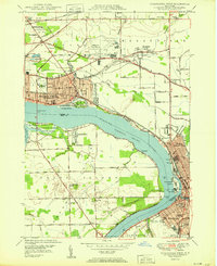
1950 Map of Tonawanda West
USGS Topo · Published 1950About this map
Niagara Falls and North Tonawanda anchor this 1950 topographical study of the riverfront and industrial interior during a period of significant post-war expansion. The map details the complex hydraulic and transport systems of the Niagara River, where the Tonawanda Channel separates the mainland from the large expanse of Grand Island. Infrastructure of the era is prominent, including the Niagara Falls Municipal Airport and the overlapping corridors of the New York Central RR and Erie RR that fueled the region's manufacturing base.
Find a feature on this map
79 named features on this map. Tap any name to fly to it.
Don’t see what you’re looking for? This feature index may not catch every label — zoom into the map to look around manually.
Map Details
Editions of this 1950 Tonawanda West Map
This is the sole edition of this map. No revisions or reprints were ever made.
Other maps of this area

1894 · Buffalo
USGS Topo · 1:62,500

1894 · Niagara Falls
USGS Topo · 1:62,500

1896 · Niagara Falls
USGS Topo · 1:62,500

1897 · Tonawanda
USGS Topo · 1:62,500

1899 · Niagara
USGS Topo · 1:125,000

1900 · Tonawanda
USGS Topo · 1:62,500

1900 · Niagara Falls
USGS Topo · 1:62,500

1901 · Buffalo
USGS Topo · 1:62,500

1901 · Niagara Falls
USGS Topo · 1:62,500

1901 · Tonawanda
USGS Topo · 1:62,500