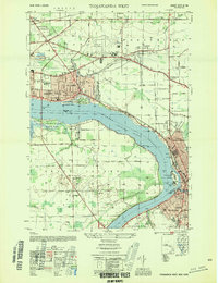
1954 Map of Tonawanda West
USGS Topo · Published 1954About this map
Grand Island and the industrial corridors of the Niagara River dominate this mid-century landscape, showing the convergence of rail, air, and water transit during a period of significant growth. The map details the residential expansion of La Salle and North Tonawanda, alongside established rural crossroads like Bergholtz and St Johnsburg. Aviation infrastructure is prominent with the Niagara Falls Municipal Airport and its associated Air Beacon.
Find a feature on this map
78 named features on this map. Tap any name to fly to it.
Don’t see what you’re looking for? This feature index may not catch every label — zoom into the map to look around manually.
Map Details
Editions of this 1954 Tonawanda West Map
This is the sole edition of this map. No revisions or reprints were ever made.
Other maps of this area

1894 · Buffalo
USGS Topo · 1:62,500

1894 · Niagara Falls
USGS Topo · 1:62,500

1896 · Niagara Falls
USGS Topo · 1:62,500

1897 · Tonawanda
USGS Topo · 1:62,500

1899 · Niagara
USGS Topo · 1:125,000

1900 · Tonawanda
USGS Topo · 1:62,500

1900 · Niagara Falls
USGS Topo · 1:62,500

1901 · Buffalo
USGS Topo · 1:62,500

1901 · Niagara Falls
USGS Topo · 1:62,500

1901 · Tonawanda
USGS Topo · 1:62,500