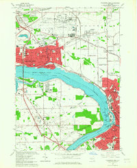
1965 Map of Tonawanda West
USGS Topo · Published 1967About this map
The Niagara River serves as the dominant geographic feature of this mid-1960s study, dividing the industrial and residential landscapes of Niagara Falls and North Tonawanda from the quieter reaches of Grand Island. The river's flow is channeled around Cayuga Island and through the Tonawada Channel, supporting a complex water infrastructure including the Lockport Intake and N Tonawanda Intake. Inland, the massive footprint of the Niagara Falls Air Force Base and the Niagara Falls International Airport dominates the northern sector, complete with the Niagara Airport Drag Strip.
Find a feature on this map
115 named features on this map. Tap any name to fly to it.
Don’t see what you’re looking for? This feature index may not catch every label — zoom into the map to look around manually.
Map Details
Editions of this 1965 Tonawanda West Map
This is the sole edition of this map. No revisions or reprints were ever made.
Other maps of this area

1894 · Buffalo
USGS Topo · 1:62,500

1894 · Niagara Falls
USGS Topo · 1:62,500

1896 · Niagara Falls
USGS Topo · 1:62,500

1897 · Tonawanda
USGS Topo · 1:62,500

1899 · Niagara
USGS Topo · 1:125,000

1900 · Tonawanda
USGS Topo · 1:62,500

1900 · Niagara Falls
USGS Topo · 1:62,500

1901 · Buffalo
USGS Topo · 1:62,500

1901 · Niagara Falls
USGS Topo · 1:62,500

1901 · Tonawanda
USGS Topo · 1:62,500