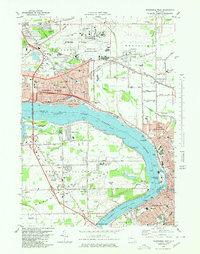
1980 Map of Tonawanda West
USGS Topo · Published 1980About this map
The Niagara River splits the landscape here, defining the borders of Niagara County and Erie County as it flows around Grand Island. This 1980 survey illustrates the heavy industrial and military footprint of the late 20th century, dominated by the Niagara Falls Air Force Base and the adjacent Niagara Falls International Airport. While the northern section around Bergholtz and St Johnsburg retains some open space, the southern reaches show dense residential development in Niagara Falls and North Tonawanda.
Find a feature on this map
94 named features on this map. Tap any name to fly to it.
Don’t see what you’re looking for? This feature index may not catch every label — zoom into the map to look around manually.
Map Details
Editions of this 1980 Tonawanda West Map
This is the sole edition of this map. No revisions or reprints were ever made.
Other maps of this area

1894 · Buffalo
USGS Topo · 1:62,500

1894 · Niagara Falls
USGS Topo · 1:62,500

1896 · Niagara Falls
USGS Topo · 1:62,500

1897 · Tonawanda
USGS Topo · 1:62,500

1899 · Niagara
USGS Topo · 1:125,000

1900 · Tonawanda
USGS Topo · 1:62,500

1900 · Niagara Falls
USGS Topo · 1:62,500

1901 · Buffalo
USGS Topo · 1:62,500

1901 · Niagara Falls
USGS Topo · 1:62,500

1901 · Tonawanda
USGS Topo · 1:62,500