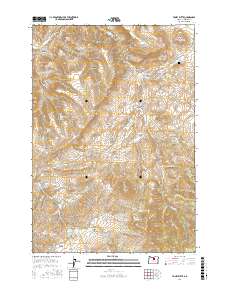
2017 Map of Toney Butte
USGS Topo · Published 2017About this map
Richmond and its surrounding high-desert plateaus define this region of Wheeler County, where the John Day River cuts through the northwest corner. The landscape is heavily marked by vertical relief, from the prominent Toney Butte and Scott Butte to the colorfully named The Blue Banks and Black Rock. For local historians and genealogists, the Richmond Cem sits just outside the small settlement, providing a fixed point of reference in an area otherwise dominated by rugged drainage systems like Shoofly Cr and Meyers Canyon. The map reveals a land utilized for water management and transit, evidenced by Keys Reservoir and cattle-country landmarks such as Gordy Flat and Camel Hump. This topographic study reflects the enduring isolation of these interior Oregon ranching lands, where seasonal springs like Quaking Aspen Spring and Rock Spring remain vital landmarks in the high country.
Find a feature on this map
44 named features on this map. Tap any name to fly to it.
Don’t see what you’re looking for? This feature index may not catch every label — zoom into the map to look around manually.
Map Details
Editions of this 2017 Toney Butte Map
This is the sole edition of this map. No revisions or reprints were ever made.
Other maps of this area

1926 · Mitchell
USGS Topo · 1:125,000

1953 · Richmond
USGS Topo · 1:62,500

1953 · Spray
USGS Topo · 1:62,500

1955 · Bend
USGS Topo · 1:250,000

1955 · Canyon City
USGS Topo · 1:250,000

1957 · Bend
USGS Topo · 1:250,000

1958 · Bend
USGS Topo · 1:250,000

1959 · Canyon City
USGS Topo · 1:250,000

1966 · Mitchell
USGS Topo · 1:62,500

1966 · Kinzua
USGS Topo · 1:62,500