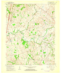
1960 Map of Tonieville
USGS Topo · Published 1962About this map
The Nolin River meanders through the heart of this landscape, its path defined by the milling and agricultural patterns of the early 1960s. Milling history is anchored by Eagle Mills and Mathers Mill, sites that historically utilized the river's descent through the limestone terrain of the Pennyroyal Plateau. Along the western edge, the Illinois Central railroad corridor passes through Glendale Junction, marking a vital transport link for the region's farms and small communities like Tonieville.
Find a feature on this map
30 named features on this map. Tap any name to fly to it.
Don’t see what you’re looking for? This feature index may not catch every label — zoom into the map to look around manually.
Map Details
Editions of this 1960 Tonieville Map
2 editions found
Other maps of this area

1934 · Munfordville
USGS Topo · 1:48,000

1935 · Elizabethtown
USGS Topo · 1:48,000

1937 · Munfordville
USGS Topo · 1:62,500

1938 · Elizabethtown
USGS Topo · 1:62,500

1948 · Cecilia
USGS Topo · 1:24,000

1949 · Sonora
USGS Topo · 1:24,000

1949 · Tonieville
USGS Topo · 1:24,000

1949 · Elizabethtown
USGS Topo · 1:24,000
1949 · Elizabethtown
USGS Topo · 1:62,500

1953 · Nelsonville
USGS Topo · 1:24,000