
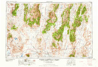
1959 Map of Tonopah
USGS Topo · Published 1959About this map
Tonopah serves as the central hub of this mid-century Nevada landscape, where the Great Basin's character is defined by north-south mountain ranges and broad desert valleys. The map documents the region's transition from early 20th-century mining booms to a mid-century era of ranching and specialized mineral extraction. Evidence of the mining legacy is found in the labels for Berlin and Grantsville, along with the Gold Hill Mill and the Liberty Mine.
Find a feature on this map
71 named features on this map. Tap any name to fly to it.
Don’t see what you’re looking for? This feature index may not catch every label — zoom into the map to look around manually.
Map Details
Editions of this 1959 Tonopah Map
2 editions found
Other maps of this area

1898 · Silver Peak
USGS Topo · 1:125,000

1900 · Silver Peak
USGS Topo · 1:125,000

1907 · Tonopah
USGS Topo · 1:250,000

1908 · Kawich
USGS Topo · 1:250,000

1908 · Lida
USGS Topo · 1:250,000

1908 · Tonopah
USGS Topo · 1:250,000

1908 · Carson Sink
USGS Topo · 1:250,000

1909 · Hawthorne
USGS Topo · 1:250,000

1910 · Carson Sink
USGS Topo · 1:250,000

1911 · Hawthorne
USGS Topo · 1:250,000