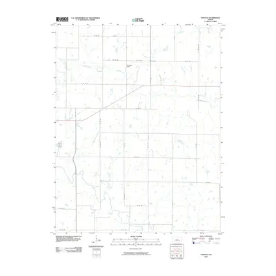
2009 Map of Tonovay
USGS Topo · Published 2009About this map
Tonovay sits at a crossroads in the rolling plains of Greenwood County, where agricultural grid roads define the modern landscape. The area is marked by the winding course of the Fall River, which meanders through the southern portion of the quadrangle, contrasted by the straighter lines of Bachelor Creek and the subtle depression of Tonovay Draw. The township road system, including routes like 180th St and 170th Stre, illustrates the persistent Section-Line organization of rural Kansas. While the settlement of Tonovay remains a focal point, the map reveals the scattered distribution of farmsteads and rural infrastructure, such as Landfill Rd, that support the local economy. This 2009 edition provides a clear view of the water drainage patterns and land use in this pocket of the Flint Hills region.
Find a feature on this map
31 named features on this map. Tap any name to fly to it.
Don’t see what you’re looking for? This feature index may not catch every label — zoom into the map to look around manually.
Map Details
Editions of this 2009 Tonovay Map
This is the sole edition of this map. No revisions or reprints were ever made.
Other maps of this area

1885 · Eureka
USGS Topo · 1:125,000

1888 · Eureka
USGS Topo · 1:125,000

1894 · Eureka
USGS Topo · 1:125,000

1939 · Severy
USGS Topo · 1:62,500

1941 · Severy
USGS Topo · 1:62,500

1955 · Wichita
USGS Topo · 1:250,000

1958 · Wichita
USGS Topo · 1:250,000
1964 · Piedmont NE
USGS Topo · 1:24,000
1969 · Neal
USGS Topo · 1:24,000
1969 · Virgil
USGS Topo · 1:24,000