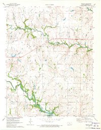
1971 Map of Tonovay
USGS Topo · Published 1973About this map
The settlement of Tonovay and the winding course of Bachelor Creek characterize this Greenwood County landscape during the early 1970s. This survey records a transition in the local economy and land use, marked by the presence of Oil Well sites and Gravel Pits scattered across the township lines. A significant portion of the southern terrain is dedicated to the Fall River State Wildlife Management Area, bordering the northern reaches of Fall River Lake. The map reveals the intricate transport network of the era, including the Atchison Topeka and Santa Fe railroad and the Missouri Pacific lines. A historical Indian Treaty Boundary cuts across the southern sections, providing a glimpse into the earlier administrative division of the Kansas plains. Detailed infrastructure like a Pipeline and a Gaging Station along the river further document the industrial footprint on this rural landscape.
Find a feature on this map
23 named features on this map. Tap any name to fly to it.
Don’t see what you’re looking for? This feature index may not catch every label — zoom into the map to look around manually.
Map Details
Editions of this 1971 Tonovay Map
This is the sole edition of this map. No revisions or reprints were ever made.
Other maps of this area

1885 · Eureka
USGS Topo · 1:125,000

1888 · Eureka
USGS Topo · 1:125,000

1894 · Eureka
USGS Topo · 1:125,000

1939 · Severy
USGS Topo · 1:62,500

1941 · Severy
USGS Topo · 1:62,500

1955 · Wichita
USGS Topo · 1:250,000

1958 · Wichita
USGS Topo · 1:250,000
1964 · Piedmont NE
USGS Topo · 1:24,000
1969 · Neal
USGS Topo · 1:24,000
1969 · Virgil
USGS Topo · 1:24,000