1969 Map of Tony Grove Creek
USGS Topo · Published 1973About this map
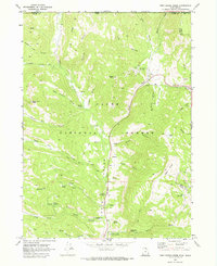
Cache National Forest straddles the high ridges and deep drainages of the Idaho and Utah border in this late-1960s survey. The landscape is defined by the winding course of the Logan River, which is fed by numerous tributaries including Tony Grove Creek, White Pine Creek, and Bunchgrass Creek. The area’s recreational and educational importance is evident in the presence of the Beaver Mtn Ski Area and the Utah State University Forestry Field Station.
Find a feature on this map
56 named features on this map. Tap any name to fly to it.
Don’t see what you’re looking for? This feature index may not catch every label — zoom into the map to look around manually.
Map Details
Editions of this 1969 Tony Grove Creek Map
This is the sole edition of this map. No revisions or reprints were ever made.
Other maps of this area

1909 · Montpelier
USGS Topo · 1:125,000

1911 · Montpelier
USGS Topo · 1:125,000

1912 · Randolph
USGS Topo · 1:125,000

1914 · Logan
USGS Topo · 1:125,000

1915 · Preston
USGS Topo · 1:96,000

1916 · Logan
USGS Topo · 1:125,000

1918 · Preston
USGS Topo · 1:125,000

1954 · Ogden
USGS Topo · 1:250,000

1955 · Preston
USGS Topo · 1:250,000

1958 · Ogden
USGS Topo · 1:250,000