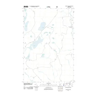
2011 Map of Toohey Lake
USGS Topo · Published 2011About this map
The Temperance River and its numerous glacial tributaries define the hydrography of this northern wilderness. In the early 21st century, the landscape is characterized by a dense network of water bodies, including Toohey Lake, Fourmile Lake, and the small Pancake Lake, interconnected by a web of Forest Service routes. A prominent feature is The Grade, a road reflecting the area's logging history and rail-bed origins, which provides access to the central interior. To the east, Sawbill Trl runs parallel to the river near the Temperance River Campground. The presence of evocative labels such as Heartbreak Creek and Wringer Lake suggests a rugged history of travel and timber extraction. This map documents a high concentration of named wetlands and smaller basins like Soda Lake and Waffle Lake, essential for understanding the local drainage patterns and ecological zones within the Superior National Forest region.
Find a feature on this map
34 named features on this map. Tap any name to fly to it.
Don’t see what you’re looking for? This feature index may not catch every label — zoom into the map to look around manually.
Map Details
Editions of this 2011 Toohey Lake Map
This is the sole edition of this map. No revisions or reprints were ever made.
Other maps of this area

1954 · Two Harbors
USGS Topo · 1:250,000

1955 · Tofte
USGS Topo · 1:24,000

1955 · Schroeder
USGS Topo · 1:24,000

1955 · Tofte
USGS Topo · 1:62,500

1955 · Cramer
USGS Topo · 1:62,500

1957 · Two Harbors
USGS Topo · 1:250,000

1958 · Two Harbors
USGS Topo · 1:250,000

1960 · Kawishiwi Lake
USGS Topo · 1:24,000

1960 · Sawbill Camp
USGS Topo · 1:24,000

1960 · Beth Lake
USGS Topo · 1:24,000