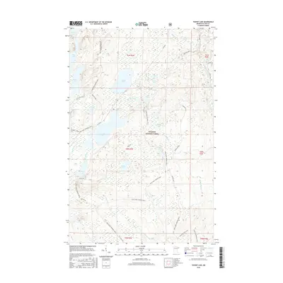
2016 Map of Toohey Lake
USGS Topo · Published 2016About this map
Superior National Forest encompasses this wilderness landscape within the Arrowhead Region of Minnesota, defined by a complex network of glacial lakes and portage routes. Central to this area is Toohey Lake, flanked by the larger Fourmile Lake and smaller bodies such as Soda Lake and Pancake Lake. This 2016 survey documents the modern infrastructure that provides access to these remote waters, including the established Sawbill Trail and the woodland corridor known as The Grade. These routes, along with the Finger Lake Access, serve as the primary conduits for recreational users and forest management. The drainage patterns of the Temperance River and Cross River further characterize the terrain, which is also crisscrossed by recreational paths like the N Shore State Trail and the Leveaux Snowmobile Trail, reflecting the dual use of the forest for both transit and leisure.
Find a feature on this map
44 named features on this map. Tap any name to fly to it.
Don’t see what you’re looking for? This feature index may not catch every label — zoom into the map to look around manually.
Map Details
Editions of this 2016 Toohey Lake Map
This is the sole edition of this map. No revisions or reprints were ever made.
Other maps of this area

1954 · Two Harbors
USGS Topo · 1:250,000

1955 · Tofte
USGS Topo · 1:24,000

1955 · Schroeder
USGS Topo · 1:24,000

1955 · Tofte
USGS Topo · 1:62,500

1955 · Cramer
USGS Topo · 1:62,500

1957 · Two Harbors
USGS Topo · 1:250,000

1958 · Two Harbors
USGS Topo · 1:250,000

1960 · Kawishiwi Lake
USGS Topo · 1:24,000

1960 · Sawbill Camp
USGS Topo · 1:24,000

1960 · Beth Lake
USGS Topo · 1:24,000