
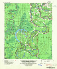
1941 Map of Tooleys
USGS Topo · Published 1946About this map
The winding Black River and Red River define this 1940s landscape, carving through the alluvial lowlands where Catahoula Parish, Concordia Parish, and Avoyelles Parish converge. The topography is dominated by water, from the massive horseshoe of Larto Lake to the complex network of bayous like Cynthia Bayou and Saline Bayou. The settlement pattern reflects a deeply river-dependent economy, evidenced by the numerous landings such as Pandora Ldg, Calhoun Ldg, and Lanius Ldg. Local history is preserved in small communities like Tooleys, Mayna, and Eva, alongside markers of early habitation at the Indian Mounds near Island Bayou Island. Inland, the terrain gives way to the dense Dismal Swamp and various brakes, while small local landmarks like the Boggy Bayou Sch and BM Graveyard provide specific points of interest for genealogical research.
Find a feature on this map
101 named features on this map. Tap any name to fly to it.
Don’t see what you’re looking for? This feature index may not catch every label — zoom into the map to look around manually.
Map Details
Editions of this 1941 Tooleys Map
2 editions found
Other maps of this area

1935 · Tooleys
USGS Topo · 1:62,500

1939 · Red Gum
USGS Topo · 1:62,500

1939 · Artonish
USGS Topo · 1:62,500

1939 · Deer Park
USGS Topo · 1:62,500

1940 · Marksville
USGS Topo · 1:62,500

1941 · Manifest
USGS Topo · 1:62,500

1941 · Jena
USGS Topo · 1:62,500

1941 · Voorhies
USGS Topo · 1:62,500

1941 · Buckeye
USGS Topo · 1:62,500

1953 · Alexandria
USGS Topo · 1:250,000