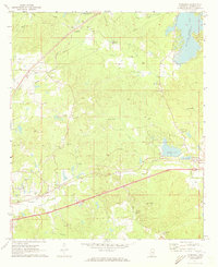
1971 Map of Toomsuba
USGS Topo · Published 1973About this map
Toomsuba and the surrounding timberlands of Lauderdale County are defined by a complex intersection of transportation and small-town infrastructure in the early 1970s. The landscape is crisscrossed by the Southern and Gulf Mobile and Ohio railroads, which served as the lifeblood for settlements like Lockhart and Russell. A notable feature of this era is the presence of the Naval Auxiliary Air Station near the northern edge, reflecting the region's mid-century military importance. Genealogists will find a high density of country churches and family burial grounds, such as Good Hope Church and the Miller Cemetery. The map also captures the local economy through numerous sandpits and the Fish Hatchery located near Bailey Lake. From the Akin Airport to the various branches of Toomsuba Creek, the map provides a look at the rural development before the expansion of modern highways altered these historic corridors.
Find a feature on this map
47 named features on this map. Tap any name to fly to it.
Don’t see what you’re looking for? This feature index may not catch every label — zoom into the map to look around manually.
Map Details
Editions of this 1971 Toomsuba Map
2 editions found
Other maps of this area

1921 · Meridian
USGS Topo · 1:48,000

1923 · Meridian
USGS Topo · 1:62,500

1953 · Meridian
USGS Topo · 1:250,000

1957 · Meridian
USGS Topo · 1:250,000

1962 · Daleville
USGS Topo · 1:24,000

1962 · Lauderdale
USGS Topo · 1:24,000

1965 · Meridian
USGS Topo · 1:250,000

1971 · Vimville
USGS Topo · 1:24,000

1971 · Meridian South
USGS Topo · 1:24,000

1971 · Meridian North
USGS Topo · 1:24,000