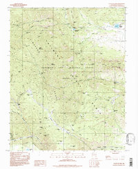
1994 Map of Tooth Of Time
USGS Topo · Published 1998About this map
Philmont Ranch defines this high-altitude landscape in the Cimarron Range, showing the complex network of backcountry camps and trails that mark the Beaubien and Miranda Grant. The terrain is dominated by sharp vertical relief, from the iconic jagged profile of the Tooth of Time and Tooth of Time Ridge to the broad expanse of Urraca Mesa. This map records a landscape managed for wilderness experience and conservation, where historic mining sites like Cyphers Mine Camp and Lambert Mine Camp have transitioned into nodes for mountain travel.
Find a feature on this map
74 named features on this map. Tap any name to fly to it.
Don’t see what you’re looking for? This feature index may not catch every label — zoom into the map to look around manually.
Map Details
Editions of this 1994 Tooth Of Time Map
This is the sole edition of this map. No revisions or reprints were ever made.
Other maps of this area

1954 · Raton
USGS Topo · 1:250,000

1955 · Cimarron
USGS Topo · 1:62,500

1955 · Ute Park
USGS Topo · 1:62,500

1956 · Tooth Of Time
USGS Topo · 1:62,500

1956 · Miami
USGS Topo · 1:62,500

1958 · Raton
USGS Topo · 1:250,000

1981 · Springer
USGS Topo · 1:100,000

1981 · Raton
USGS Topo · 1:100,000

1982 · Wheeler Peak
USGS Topo · 1:100,000

1983 · Taos
USGS Topo · 1:100,000