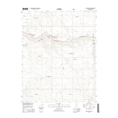
2014 Map of Toothpick Ridge
USGS Topo · Published 2014About this map
Kaibab National Forest defines this high-elevation landscape, where deep drainages like Toothpick Canyon and Wildband Canyon carve through the plateau. Water management is the primary human footprint in this wilderness area, evidenced by a network of catchments and natural sources such as Pigeon Tank, Slide Tank, and Table Rock Spring. These water points serve as vital landmarks across the undulating terrain of Toothpick Ridge and Suicide Ridge.
Find a feature on this map
35 named features on this map. Tap any name to fly to it.
Don’t see what you’re looking for? This feature index may not catch every label — zoom into the map to look around manually.
Map Details
Editions of this 2014 Toothpick Ridge Map
This is the sole edition of this map. No revisions or reprints were ever made.
Other maps of this area

1886 · Kaibab
USGS Topo · 1:250,000

1953 · Grand Canyon
USGS Topo · 1:250,000

1954 · Fredonia
USGS Topo · 1:62,500

1957 · Grand Canyon
USGS Topo · 1:250,000

1957 · Shinarump SE
USGS Topo · 1:24,000

1957 · Shinarump SW
USGS Topo · 1:24,000
1957 · Shinarump
USGS Topo · 1:62,500

1957 · Jumpup Canyon
USGS Topo · 1:62,500

1958 · Grand Canyon
USGS Topo · 1:250,000

1958 · Big Springs
USGS Topo · 1:62,500