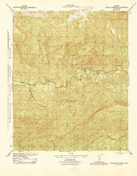
1944 Map of Topatopa Mountains
USGS Topo · Published 1944About this map
Sespe Game Refuge dominates the landscape of this 1940s Forest Service survey, showcasing a preserved wilderness within the Los Padres National Forest. The drainage system of Sespe Creek and its many tributaries, including West Fork Sespe Creek and Mutau Creek, define the complex topography. While the area is largely undeveloped, the presence of the Hartman Guard Sta indicates the active management of these lands by the War Department and Department of Agriculture during the war years. High points such as Hines Peak and San Rafael Pk overlook several notable level areas used for grazing or camp locations, such as Ten Sycamore Flat, Oak Flat, and Mutau Flat. These pockets of flat ground amid the Topatopa Mountains served as critical landmarks for rangers and backcountry travelers navigating the steep canyons of Bear Canyon and Lion Canyon.
Find a feature on this map
22 named features on this map. Tap any name to fly to it.
Don’t see what you’re looking for? This feature index may not catch every label — zoom into the map to look around manually.
Map Details
Editions of this 1944 Topatopa Mountains Map
This is the sole edition of this map. No revisions or reprints were ever made.
Other maps of this area

1900 · Piru
USGS Topo · 1:62,500

1903 · Santa Paula
USGS Topo · 1:62,500

1903 · Mt. Pinos
USGS Topo · 1:125,000

1903 · Tejon
USGS Topo · 1:125,000

1903 · Camulos
USGS Topo · 1:125,000

1921 · Piru
USGS Topo · 1:62,500

1941 · Piru
USGS Topo · 1:62,500

1942 · Santa Paula
USGS Topo · 1:62,500

1943 · Topatopa Mountains
USGS Topo · 1:24,000

1943 · San Guillermo
USGS Topo · 1:24,000