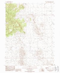
1988 Map of Topaz Mountain East
USGS Topo · Published 1989About this map
Topaz Mountain anchors the high ground of the Thomas Range in this late-century survey of the Utah desert. The landscape is defined by its geological and mining potential, evidenced by numerous excavations labeled simply as Prospect or Prospects scattered throughout the foothills. The terrain transitions from the jagged peaks of Starvation Canyon and Picture Rock into the broad, arid basins of Topaz Valley and Little Valley. This area, managed by the Juab Co jurisdiction, reflects a wilderness characterized by seasonal water drainage like Rock Wash and the isolated Dead Horse Tank. North of Antelope Ridge, the Pismire Knolls provide distinct landmarks for navigators and mineral hunters tracing the geological seams of this mineral-rich corridor.
Find a feature on this map
15 named features on this map. Tap any name to fly to it.
Don’t see what you’re looking for? This feature index may not catch every label — zoom into the map to look around manually.
Map Details
Editions of this 1988 Topaz Mountain East Map
This is the sole edition of this map. No revisions or reprints were ever made.
Other maps of this area

1885 · Sevier Desert
USGS Topo · 1:250,000

1908 · Fish Springs
USGS Topo · 1:250,000

1910 · Fish Springs
USGS Topo · 1:250,000

1953 · Dugway Pass
USGS Topo · 1:24,000

1953 · Dugway Range
USGS Topo · 1:62,500

1953 · Topaz Mtn
USGS Topo · 1:62,500

1953 · Delta
USGS Topo · 1:250,000

1958 · Delta
USGS Topo · 1:250,000

1962 · Delta
USGS Topo · 1:250,000

1971 · Picture Rock Hills
USGS Topo · 1:24,000