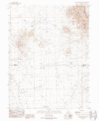
1988 Map of Topaz Mountain SW
USGS Topo · Published 1989About this map
Whirlwind Valley and the Wildcat Hills define this high desert landscape along the border of Juab and Millard Counties. Mapping from late 1980s aerial photography shows a complex network of intermittent watercourses, including Swasey Wash and Fish Springs Wash, which drain the arid basins and surrounding uplands. A rare permanent water source, Swasey Springs, is located at the base of the western slopes, a critical point for local land use and survival in this environment. The presence of Dry Lake Creek and the broad alluvial flats of the Bottom area near the Swasey region suggest seasonal patterns of runoff and collection. This survey provides an essential view of the hydrography of the Great Basin just before the turn of the 21st century, detailing the small topographic variations like the Knolls and the entrance to Horse Valley.
Find a feature on this map
11 named features on this map. Tap any name to fly to it.
Don’t see what you’re looking for? This feature index may not catch every label — zoom into the map to look around manually.
Map Details
Editions of this 1988 Topaz Mountain SW Map
This is the sole edition of this map. No revisions or reprints were ever made.
Other maps of this area

1908 · Fish Springs
USGS Topo · 1:250,000

1910 · Fish Springs
USGS Topo · 1:250,000

1953 · Topaz Mtn
USGS Topo · 1:62,500

1953 · Delta
USGS Topo · 1:250,000

1958 · Delta
USGS Topo · 1:250,000

1962 · Delta
USGS Topo · 1:250,000

1967 · Sand Pass SE
USGS Topo · 1:24,000
1967 · Sand Pass NE
USGS Topo · 1:24,000
1972 · Swasey Peak
USGS Topo · 1:24,000
1972 · Little Drum Pass
USGS Topo · 1:24,000