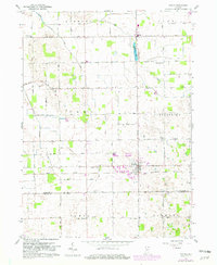
1959 Map of Topeka
USGS Topo · Published 1982About this map
Topeka serves as the primary hub of this landscape, situated at the intersection of the Norfolk and Western rail line and various rural routes. The map illustrates a structured agricultural community defined by the townships of Newbury, Eden, and Clearspring. This 1959 survey, updated with 1979 photorevisions, provides a detailed view of the rural infrastructure in Northern Indiana, showing numerous small cemeteries such as Hawpatch Cem and Maple Grove Cem that offer important clues for genealogical research. The landscape is characterized by a high density of rural schools, including Wortinger Sch and Walnut Sch, alongside local landmarks like Salem Ch. The winding course of the Elkhart River and the presence of Emma Lake highlight the natural drainage patterns of the region, while scattered Gravel Pits indicate localized extraction efforts essential to the area's development.
Find a feature on this map
24 named features on this map. Tap any name to fly to it.
Don’t see what you’re looking for? This feature index may not catch every label — zoom into the map to look around manually.
Map Details
Editions of this 1959 Topeka Map
2 editions found
Other maps of this area

1947 · Lagrange
USGS Topo · 1:24,000

1947 · Oliver Lake
USGS Topo · 1:24,000

1951 · Wawasee
USGS Topo · 1:24,000

1953 · Fort Wayne
USGS Topo · 1:250,000

1956 · Fort Wayne
USGS Topo · 1:250,000

1956 · Ligonier
USGS Topo · 1:24,000

1956 · Albion
USGS Topo · 1:24,000

1959 · Topeka
USGS Topo · 1:24,000
1959 · Oliver Lake
USGS Topo · 1:24,000

1959 · Millersburg
USGS Topo · 1:24,000