1969 Map of Topo Valley
USGS Topo · Published 1984About this map
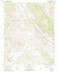
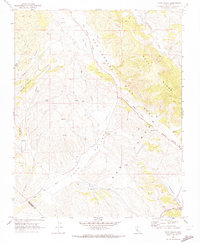
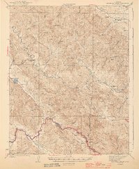
The San Andreas Rift Zone dominates the structural geography of this San Benito County landscape, carving a distinct corridor between Buck Ridge and the western canyons. This 1969 field survey illustrates a sparsely settled ranching region where remote outposts like Sanz Ranch and Tannehill Ranch are connected by seasonal water sources and dirt tracks. The terrain is characterized by a series of parallel valleys, including Little Rabbit Valley and Rabbit Valley, which follow the seismic fault line. Local infrastructure is minimal, represented by scattered Water Tanks, a Quarry near the San Benito River, and small aviation Landing Strips. The drainage pattern is complex, with Topo Creek and Bitterwater Creek navigating the deep incisions of Wildhorse Canyon and George Hansen Canyon.
Find a feature on this map
28 named features on this map. Tap any name to fly to it.
Don’t see what you’re looking for? This feature index may not catch every label — zoom into the map to look around manually.
Map Details
Editions of this 1969 Topo Valley Map
2 editions found
Other maps of this area

1912 · Metz
USGS Topo · 1:31,680

1913 · Panoche
USGS Topo · 1:125,000

1915 · Priest Valley
USGS Topo · 1:125,000

1919 · San Benito
USGS Topo · 1:62,500

1921 · Metz
USGS Topo · 1:62,500
1931 · San Benito
USGS Topo · 1:62,500

1940 · Metz
USGS Topo · 1:62,500
1940 · San Benito
USGS Topo · 1:62,500

1943 · Hernandez Valley
USGS Topo · 1:62,500
1944 · Hernandez Valley
USGS Topo · 1:62,500