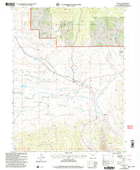
2000 Map of Toponas
USGS Topo · Published 2004About this map
Egeria Park serves as the focal point of this high-elevation landscape, where the open basin of Egeria meets the rising slopes of King Mountain and Five Pine Mesa. This corner of Northwest Colorado is characterized by its complex water management systems, including the Stillwater Ditch and Five Pine Mesa Ditch, which redirect snowmelt from the Routt National Forest to sustain the ranching and agricultural operations below. The small settlement of Toponas marks a vital crossroads, situated near the distinctive Toponas Rock landmark. To the north, the terrain becomes more rugged as it climbs toward Lone Spring Butte, while the valley floor is dotted with reservoirs such as Crowner Reservoir and Kelly Reservoir. The presence of a Landing Strip and a Gravel Pit indicates the modern utility and logistical needs of this working landscape at the turn of the 21st century.
Find a feature on this map
32 named features on this map. Tap any name to fly to it.
Don’t see what you’re looking for? This feature index may not catch every label — zoom into the map to look around manually.
Map Details
Editions of this 2000 Toponas Map
This is the sole edition of this map. No revisions or reprints were ever made.
Other maps of this area

1954 · Craig
USGS Topo · 1:250,000

1956 · Gore Pass
USGS Topo · 1:62,500

1957 · Craig
USGS Topo · 1:250,000

1957 · Leadville
USGS Topo · 1:250,000

1958 · Craig
USGS Topo · 1:250,000

1959 · Leadville
USGS Topo · 1:250,000

1960 · Leadville
USGS Topo · 1:250,000

1960 · Craig
USGS Topo · 1:250,000

1962 · Leadville
USGS Topo · 1:250,000

1962 · Craig
USGS Topo · 1:250,000