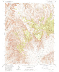
1961 Map of Topopah Spring
USGS Topo · Published 1979About this map
The Nevada Test Site dominates this 1961 landscape, a high-desert terrain marked by deep canyons and prominent peaks in Nye County. Surveyed just as the atomic age was transforming this remote territory, the map reveals a complex network of geological features and early-century infrastructure. The namesake Topopah Spring sits on the eastern slopes of Shoshone Mountain, while the Calico Hills rise in the south. This area, largely defined by drainage systems like Topopah Wash and Fortymile Canyon, shows evidence of mineral exploration with isolated prospects and mines. The presence of the Topopah Trail and various jeep trails suggests a transition from traditional land use to the specialized military and scientific operations of the mid-20th century. High points such as Shoshone Peak and Water Pipe Butte served as critical landmarks for both early travelers and modern surveyors.
Find a feature on this map
31 named features on this map. Tap any name to fly to it.
Don’t see what you’re looking for? This feature index may not catch every label — zoom into the map to look around manually.
Map Details
Editions of this 1961 Topopah Spring Map
3 editions found
Other maps of this area

1908 · Kawich
USGS Topo · 1:250,000

1908 · Furnace Creek
USGS Topo · 1:250,000

1910 · Furnace Creek
USGS Topo · 1:250,000

1942 · Wheelbarrow Peak
USGS Topo · 1:125,000

1942 · Skull Mountain
USGS Topo · 1:125,000

1948 · Death Valley
USGS Topo · 1:250,000

1952 · Topopah Spring
USGS Topo · 1:62,500

1952 · Tippipah Spring
USGS Topo · 1:62,500

1952 · Timber Mountain
USGS Topo · 1:62,500
1952 · Cane Spring
USGS Topo · 1:62,500