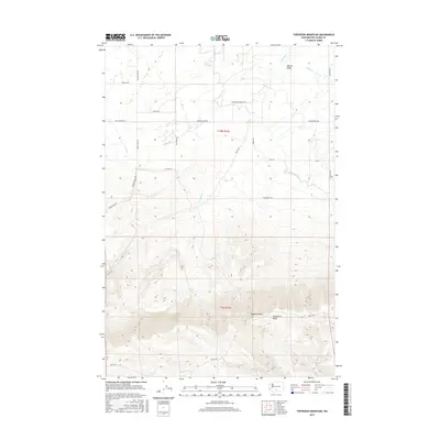
2017 Map of Toppenish Mountain
USGS Topo · Published 2017About this map
Yakima Valley transitions into the steep, rising elevation of the Cascade foothills in this detailed topographic study of Yakima County. The landscape is dominated by the massive profile of Toppenish Mtn and the long, high alignment of Toppenish Ridge, which together dictate the flow of local hydrology toward the valley floor. Water management is a central theme of the northern half of the map, where the Unit 2 Canal and Marion Drain Rd reflect the agricultural engineering necessary for this region, while higher elevations maintain natural water features like Olney Lake and Seattle Spring. A network of Bureau of Indian Affairs and local roads, such as Mission Rd, Shaker Church Rd, and Fort Simcoe Rd, provides access across the shifting terrain, connecting the irrigated plains to the timbered ridges and drainages of Toppenish Cr.
Find a feature on this map
26 named features on this map. Tap any name to fly to it.
Don’t see what you’re looking for? This feature index may not catch every label — zoom into the map to look around manually.
Map Details
Editions of this 2017 Toppenish Mountain Map
This is the sole edition of this map. No revisions or reprints were ever made.
Other maps of this area

1937 · White Swan
USGS Topo · 1:125,000

1950 · Yakima
USGS Topo · 1:250,000

1958 · Toppenish Mtn.
USGS Topo · 1:24,000

1958 · Harrah
USGS Topo · 1:24,000

1958 · Fort Simcoe
USGS Topo · 1:24,000

1958 · Fort Simcoe
USGS Topo · 1:62,500

1958 · White Swan
USGS Topo · 1:24,000
1958 · Medicine Valley
USGS Topo · 1:24,000

1958 · Harrah SE
USGS Topo · 1:24,000

1958 · Yakima
USGS Topo · 1:250,000