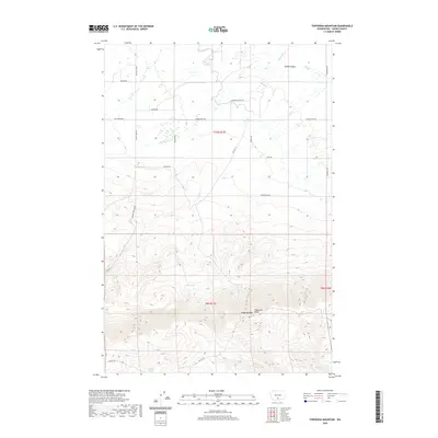
2020 Map of Toppenish Mountain
USGS Topo · Published 2020About this map
The Toppenish Mtn Ridge rises sharply from the southern edge of the Yakima Valley, creating a landscape defined by dramatic elevation changes and essential water management. In the valley floor, the Unit 2 Canal and a network of arterial roads like Fort Simcoe Rd and Chaker Church Rd support the region's agricultural infrastructure. The transition from the cultivated lowlands to the high ridges is marked by the path of Toppenish Cr, which flows eastward toward the valley floor. High-elevation features like Olney Lake and the remote Seattle Spring feed the drainage systems of Seattle Cr and Mill Cr. This 2020 topographical study captures the intersection of managed water resources and the natural timbered slopes of the tribal lands and public reserves in south-central Washington.
Find a feature on this map
26 named features on this map. Tap any name to fly to it.
Don’t see what you’re looking for? This feature index may not catch every label — zoom into the map to look around manually.
Map Details
Editions of this 2020 Toppenish Mountain Map
This is the sole edition of this map. No revisions or reprints were ever made.
Other maps of this area

1937 · White Swan
USGS Topo · 1:125,000

1950 · Yakima
USGS Topo · 1:250,000

1958 · Toppenish Mtn.
USGS Topo · 1:24,000

1958 · Harrah
USGS Topo · 1:24,000

1958 · Fort Simcoe
USGS Topo · 1:24,000

1958 · Fort Simcoe
USGS Topo · 1:62,500

1958 · White Swan
USGS Topo · 1:24,000
1958 · Medicine Valley
USGS Topo · 1:24,000

1958 · Harrah SE
USGS Topo · 1:24,000

1958 · Yakima
USGS Topo · 1:250,000