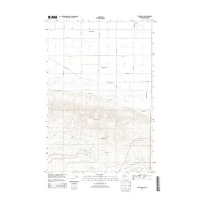
2014 Map of Toppenish SW
USGS Topo · Published 2014About this map
Yakima Valley agricultural lands transition into the dramatic rising slopes of the Toppenish Ridge on this 2014 survey. The northern half of the map is defined by a rigorous grid of section lines and irrigation-influenced infrastructure, including the Marion Drain RD and Lateral A RD, reflecting the systematic water management essential to the region's productivity. In the northeast corner, the campus of Heritage Univ serves as a prominent modern landmark near the intersection of S McKinley RD and Larue RD. To the south, the terrain becomes increasingly complex as the landscape climbs toward a prominent geographical formation known as Hole in the Wall. This rugged southern sector is dissected by several seasonal and permanent watercourses, including Snake Cr, Dry Cr, and Satus Cr, which carve through the high ground of the t9n r19e township.
Find a feature on this map
26 named features on this map. Tap any name to fly to it.
Don’t see what you’re looking for? This feature index may not catch every label — zoom into the map to look around manually.
Map Details
Editions of this 2014 Toppenish SW Map
This is the sole edition of this map. No revisions or reprints were ever made.
Other maps of this area

1910 · Zillah
USGS Topo · 1:125,000

1937 · White Swan
USGS Topo · 1:125,000

1950 · Yakima
USGS Topo · 1:250,000

1958 · Hembre Mtn
USGS Topo · 1:24,000

1958 · Toppenish SW
USGS Topo · 1:24,000

1958 · Harrah
USGS Topo · 1:24,000
1958 · Toppenish
USGS Topo · 1:24,000

1958 · Harrah SE
USGS Topo · 1:24,000
1958 · Wapato
USGS Topo · 1:24,000

1958 · Yakima
USGS Topo · 1:250,000