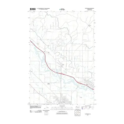
2011 Map of Toppenish
USGS Topo · Published 2011About this map
The Yakima River and its meandering Wanity Slough define the fertile valley landscape in this 2011 survey of Yakima County. The city of Toppenish serves as a significant regional hub, characterized by a structured street grid that gives way to the expansive agricultural plots of the surrounding countryside. This irrigation-heavy region is woven together by a dense network of local roads like Lombard Loop Rd and Nightingale Rd. To the north, the community of Zillah is situated across the river from Keck, while Buena and the nearby Buena Airport anchor the northwestern portion of the map near Flint and Sawyer. The terrain rises toward the northeast near Racehorse Canyon, providing a contrast to the river bottomlands. For those researching local family history, the McCoy Cemetery and various rural crossings such as Wesley Junction provide specific points of geographic interest in this well-developed agricultural corridor.
Find a feature on this map
98 named features on this map. Tap any name to fly to it.
Don’t see what you’re looking for? This feature index may not catch every label — zoom into the map to look around manually.
Map Details
Editions of this 2011 Toppenish Map
This is the sole edition of this map. No revisions or reprints were ever made.
Other maps of this area

1910 · Zillah
USGS Topo · 1:125,000

1936 · Yakima East
USGS Topo · 1:48,000

1936 · Hog Ranch Buttes
USGS Topo · 1:48,000

1941 · Black Rock Spring
USGS Topo · 1:62,500

1941 · Yakima East
USGS Topo · 1:62,500

1950 · Yakima
USGS Topo · 1:250,000
1953 · Black Rock Spring SW
USGS Topo · 1:24,000

1953 · Elephant Mountain
USGS Topo · 1:24,000

1953 · Yakima East
USGS Topo · 1:24,000
1953 · Black Rock Spring
USGS Topo · 1:62,500