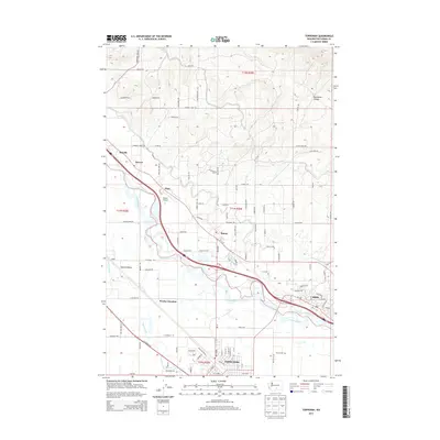
2013 Map of Toppenish
USGS Topo · Published 2013About this map
The Yakima River winds through the heart of the Yakima Valley, creating a landscape defined by its irrigation and transportation networks in the early 21st century. This 2013 survey captures the agricultural corridors connecting Toppenish, Zillah, and Buena. The topography reveals the contrast between the flat river bottoms near Wanity Slough and the rising ground of Racehorse Canyon to the northeast. Small settlements and former stops like Donald, Sawyer, and Wesley Junction dot the valley floor, while infrastructure such as the Buena Airport and McCoy Cem near the southern edge provide specific points of interest for local history. The map's grid is dominated by orchards and farm roads, reflecting the region's enduring role as a central Washington hub for fruit production and transit.
Find a feature on this map
99 named features on this map. Tap any name to fly to it.
Don’t see what you’re looking for? This feature index may not catch every label — zoom into the map to look around manually.
Map Details
Editions of this 2013 Toppenish Map
This is the sole edition of this map. No revisions or reprints were ever made.
Other maps of this area

1910 · Zillah
USGS Topo · 1:125,000

1936 · Yakima East
USGS Topo · 1:48,000

1936 · Hog Ranch Buttes
USGS Topo · 1:48,000

1941 · Black Rock Spring
USGS Topo · 1:62,500

1941 · Yakima East
USGS Topo · 1:62,500

1950 · Yakima
USGS Topo · 1:250,000
1953 · Black Rock Spring SW
USGS Topo · 1:24,000

1953 · Elephant Mountain
USGS Topo · 1:24,000

1953 · Yakima East
USGS Topo · 1:24,000
1953 · Black Rock Spring
USGS Topo · 1:62,500