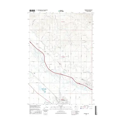
2017 Map of Toppenish
USGS Topo · Published 2017About this map
The Yakima River defines the central axis of this landscape, carving through the Yakima Valley as it flows past a network of agricultural settlements and irrigation infrastructure. The Sunnyside Canal runs parallel to the river, a critical component of the region's water management system that supports the surrounding orchards and fields. To the south, Toppenish serves as a primary hub, while smaller communities like Buena, Zillah, Sawyer, and Flint are connected by the Yakima Valley Hwy and a dense grid of rural roads. North of the river, the terrain rises toward Racehorse Canyon, where the elevation increases significantly compared to the fertile river bottom. Local history and genealogy are anchored by landmarks such as the McCoy Cem and the Buena Airport, reflecting the area's development as an essential corridor for transportation and agriculture in Yakima County.
Find a feature on this map
78 named features on this map. Tap any name to fly to it.
Don’t see what you’re looking for? This feature index may not catch every label — zoom into the map to look around manually.
Map Details
Editions of this 2017 Toppenish Map
This is the sole edition of this map. No revisions or reprints were ever made.
Other maps of this area

1910 · Zillah
USGS Topo · 1:125,000

1936 · Yakima East
USGS Topo · 1:48,000

1936 · Hog Ranch Buttes
USGS Topo · 1:48,000

1941 · Black Rock Spring
USGS Topo · 1:62,500

1941 · Yakima East
USGS Topo · 1:62,500

1950 · Yakima
USGS Topo · 1:250,000
1953 · Black Rock Spring SW
USGS Topo · 1:24,000

1953 · Elephant Mountain
USGS Topo · 1:24,000

1953 · Yakima East
USGS Topo · 1:24,000
1953 · Black Rock Spring
USGS Topo · 1:62,500