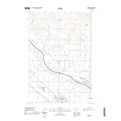
2020 Map of Toppenish
USGS Topo · Published 2020About this map
The Yakima Valley unfolds as an intricate network of irrigation and agriculture, anchored by the city of Toppenish. The landscape is defined by the heavy engineering of the Sunnyside Canal, Roza Canal, and Union Gap Canal, which channel water across the valley floor to support the region's orchards and fields. Small agricultural settlements like Buena, Zillah, and Sawyer are situated along the transit corridors, while the Yakima River and Wanity Slough provide the natural drainage for the basin. To the northeast, the terrain rises into the foothills, marked by the prominent Racehorse Canyon. Local landmarks such as the Buena Airport and the McCoy Cem offer specific points of interest for genealogists and local historians tracing the development of this Yakima County corridor. The dense grid of rural roads, including Price Orchard RD and Lombard Loop RD, illustrates the intensive land use of this productive fruit-growing district.
Find a feature on this map
105 named features on this map. Tap any name to fly to it.
Don’t see what you’re looking for? This feature index may not catch every label — zoom into the map to look around manually.
Map Details
Editions of this 2020 Toppenish Map
This is the sole edition of this map. No revisions or reprints were ever made.
Other maps of this area

1910 · Zillah
USGS Topo · 1:125,000

1936 · Yakima East
USGS Topo · 1:48,000

1936 · Hog Ranch Buttes
USGS Topo · 1:48,000

1941 · Black Rock Spring
USGS Topo · 1:62,500

1941 · Yakima East
USGS Topo · 1:62,500

1950 · Yakima
USGS Topo · 1:250,000
1953 · Black Rock Spring SW
USGS Topo · 1:24,000

1953 · Elephant Mountain
USGS Topo · 1:24,000

1953 · Yakima East
USGS Topo · 1:24,000
1953 · Black Rock Spring
USGS Topo · 1:62,500