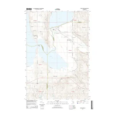
2014 Map of Torch River
USGS Topo · Published 2014About this map
Torch Lake and Lake Skegemog dominate this 2014 survey of the Chain o' Lakes region, where three Michigan counties—Antrim, Kalkaska, and Grand Traverse—converge. The settlement of Torch River sits at the narrow waterway connecting the two major lakes, serving as a focal point for the surrounding residential developments and camps such as Morgan Shores Road and Chippewa Camp Road. To the east, the landscape transitions from the lakefront into the basin of the Rapid River, which flows toward the village of Rapid City.
Find a feature on this map
93 named features on this map. Tap any name to fly to it.
Don’t see what you’re looking for? This feature index may not catch every label — zoom into the map to look around manually.
Map Details
Editions of this 2014 Torch River Map
This is the sole edition of this map. No revisions or reprints were ever made.
Other maps of this area

1954 · Traverse City
USGS Topo · 1:250,000

1956 · Mancelona
USGS Topo · 1:62,500

1956 · Kalkaska
USGS Topo · 1:62,500

1956 · Fife Lake
USGS Topo · 1:62,500

1957 · Elk Rapids
USGS Topo · 1:62,500

1958 · Traverse City
USGS Topo · 1:250,000

1975 · Mancelona NW
USGS Topo · 1:24,000

1983 · Traverse City
USGS Topo · 1:100,000
1983 · Elk Rapids
USGS Topo · 1:25,000
1983 · Alden
USGS Topo · 1:24,000