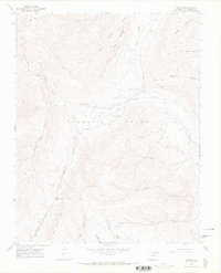
1967 Map of Torres
USGS Topo · Published 1971About this map
The Maxwell Land Grant dominates this 1967 survey of the Las Animas high country, where the headwaters of the South Fork Purgatoire River meet a landscape shaped by early ranching and resource extraction. The small settlement of Torres serves as a central point in a terrain marked by complex water management, including the Consolidated Ditch and Quatro Ditch. To the east, the remains of an Old Railroad Grade and the Tercio Cem provide evidence of the area's industrial past, likely tied to the nearby Cornell Mine and Quatro Mine. Dramatic geological formations like The Stonewall and The Little Wall define the vertical relief, while isolated outposts such as Davenport Cabin and Sheep Camp suggest the seasonal rhythms of high-altitude life before modern development altered these remote Colorado valleys.
Find a feature on this map
34 named features on this map. Tap any name to fly to it.
Don’t see what you’re looking for? This feature index may not catch every label — zoom into the map to look around manually.
Map Details
Editions of this 1967 Torres Map
4 editions found
Other maps of this area

1891 · Spanish Peaks
USGS Topo · 1:125,000

1893 · Spanish Peaks
USGS Topo · 1:125,000

1895 · Spanish Peaks
USGS Topo · 1:125,000

1897 · Spanish Peaks
USGS Topo · 1:125,000

1900 · Spanish Peaks
USGS Topo · 1:125,000

1954 · Raton
USGS Topo · 1:250,000

1954 · Trinidad
USGS Topo · 1:250,000

1955 · Trinidad
USGS Topo · 1:250,000

1958 · Raton
USGS Topo · 1:250,000

1958 · Trinidad
USGS Topo · 1:250,000