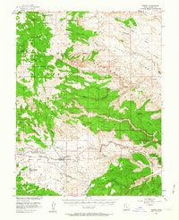
1952 Map of Torrey
USGS Topo · Published 1964About this map
The high desert and alpine landscapes of Wayne County meet in this survey conducted in cooperation with the Atomic Energy Commission. The settlements of Torrey and Teasdale are the primary hubs of human activity, situated south of the massive Thousand Lake Mountain. This area is characterized by a complex network of canyons and mesas, including Meeks Mesa and Cooks Mesa, which transition into the dramatic uplift of the Waterpocket Fold.
Find a feature on this map
69 named features on this map. Tap any name to fly to it.
Don’t see what you’re looking for? This feature index may not catch every label — zoom into the map to look around manually.
Map Details
Editions of this 1952 Torrey Map
3 editions found

Other maps of this area

1885 · Fish Lake
USGS Topo · 1:250,000

1896 · Fish Lake
USGS Topo · 1:250,000

1952 · Notom 2 NW
USGS Topo · 1:24,000

1952 · Loa 1 SE
USGS Topo · 1:24,000

1952 · Notom 3 NW
USGS Topo · 1:24,000

1952 · Notom 2 SE
USGS Topo · 1:24,000

1952 · Notom 2 SW
USGS Topo · 1:24,000

1952 · Notom 4 NW
USGS Topo · 1:24,000

1952 · Notom 2 NE
USGS Topo · 1:24,000

1952 · Notom 3 NE
USGS Topo · 1:24,000