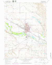
1963 Map of Torrington
USGS Topo · Published 1979About this map
The North Platte River serves as the focal point for this 1963 survey of Goshen County, where the landscape is defined by a complex network of irrigation and transportation. The city of Torrington and its neighbor South Torrington are depicted as hubs of activity, featuring the Goshen county Court House, City Hall, and St Josephs Orphanage. This map provides a detailed view of the region's agricultural infrastructure, including the Interstate Canal, Torrington Ditch, and Arnold Dam.
Find a feature on this map
38 named features on this map. Tap any name to fly to it.
Don’t see what you’re looking for? This feature index may not catch every label — zoom into the map to look around manually.
Map Details
Editions of this 1963 Torrington Map
2 editions found
Other maps of this area

1896 · Patrick
USGS Topo · 1:125,000

1899 · Goshen Hole
USGS Topo · 1:125,000

1954 · Torrington
USGS Topo · 1:250,000

1954 · Cheyenne
USGS Topo · 1:250,000

1958 · Cheyenne
USGS Topo · 1:250,000

1958 · Torrington
USGS Topo · 1:250,000

1960 · Huntley
USGS Topo · 1:24,000

1960 · Lyman
USGS Topo · 1:24,000
1960 · Cottier
USGS Topo · 1:24,000
1960 · Yoder
USGS Topo · 1:24,000