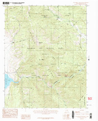
1987 Map of Touch-Me-Not Mountain
USGS Topo · Published 1987About this map
Philmont Scout Ranch dominates the northern half of this landscape, characterized by a network of trail camps such as Black Horse Camp, Miranda Camp, and Ute Meadows Camp. The terrain is defined by the high peaks of the Cimarron Range, including the prominent Touch-Me-Not Mountain and Green Mountain. This 1980s survey captures a transition between managed wilderness and resource extraction, shown by the proximity of the Horseshoe Mine and various Prospect sites to the Colin Neblett State Wildlife Area. To the west, the shoreline of Eagle Nest Lake meets the slopes near the site of Virginia City. The map details the drainage patterns of the Cimarron Canyon, where the Cimarron River is fed by tributaries like Maverick Creek and Tolby Creek. Cultural landmarks such as a remote Cemetery and Radio Towers are noted among the steep contours of the Beaubien and Miranda Grant.
Find a feature on this map
33 named features on this map. Tap any name to fly to it.
Don’t see what you’re looking for? This feature index may not catch every label — zoom into the map to look around manually.
Map Details
Editions of this 1987 Touch-Me-Not Mountain Map
This is the sole edition of this map. No revisions or reprints were ever made.
Other maps of this area

1954 · Raton
USGS Topo · 1:250,000

1955 · Ute Park
USGS Topo · 1:62,500

1956 · Tooth Of Time
USGS Topo · 1:62,500

1958 · Raton
USGS Topo · 1:250,000

1963 · Eagle Nest
USGS Topo · 1:24,000

1963 · Red River Pass
USGS Topo · 1:24,000

1965 · Palo Flechado Pass
USGS Topo · 1:24,000

1982 · Wheeler Peak
USGS Topo · 1:100,000

1983 · Taos
USGS Topo · 1:100,000
1987 · Ute Park
USGS Topo · 1:24,000