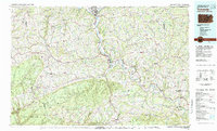
1981 Map of Towanda
USGS Topo · Published 1982About this map
The Susquehanna River carves a deep valley through the Endless Mountains region, serving as the central corridor for industry and transit in the early 1980s. Along its banks, the manufacturing and rail hubs of Sayre, Athens, and South Waverly form a dense cluster at the New York border, where the Conrail line and Chemung River converge. This survey captures a landscape defined by sharp elevation shifts, from the heights of Armenia Mountain in the west to the conservation lands of State Game Lands No 12 and Tiadaghton State Forest. The map documents the rural network of the county seat at Towanda, surrounded by numerous smaller townships like Sheshequin and Rome, illustrating a region where the rugged terrain has long dictated the path of settlements and secondary roads like U.S. 6.
Find a feature on this map
141 named features on this map. Tap any name to fly to it.
Don’t see what you’re looking for? This feature index may not catch every label — zoom into the map to look around manually.
Map Details
Editions of this 1981 Towanda Map
This is the sole edition of this map. No revisions or reprints were ever made.
Other maps of this area

1891 · Harveys Lake
USGS Topo · 1:62,500

1893 · Harvey Lake
USGS Topo · 1:62,500

1893 · Pittston
USGS Topo · 1:62,500

1895 · Elmira
USGS Topo · 1:62,500

1900 · Tioga
USGS Topo · 1:62,500

1901 · Apalachin
USGS Topo · 1:62,500

1902 · Waverly
USGS Topo · 1:62,500

1902 · Tioga
USGS Topo · 1:62,500

1903 · Owego
USGS Topo · 1:62,500

1904 · Binghamton
USGS Topo · 1:62,500