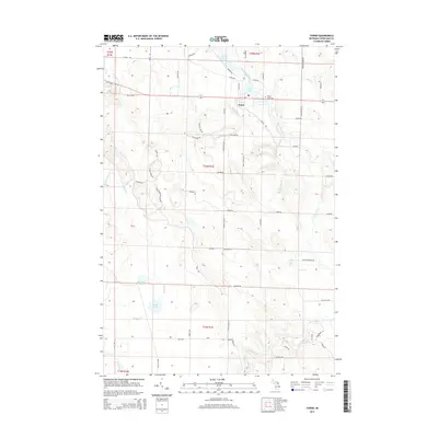
2014 Map of Tower
USGS Topo · Published 2014About this map
Tower and its surrounding riverine landscape are defined by the winding course of the Black River in this 2014 survey. The river's path is interrupted by the significant impoundments of Kleber Pond and Tower Pond, while further downstream, the waters pass over Crockett Rapids. This area of Cheboygan County features a network of rural roads such as Old M-68 Ext and Center Line Rd that connect small water bodies like McLavey Lake and Dorsey Lake.
Find a feature on this map
65 named features on this map. Tap any name to fly to it.
Don’t see what you’re looking for? This feature index may not catch every label — zoom into the map to look around manually.
Map Details
Editions of this 2014 Tower Map
This is the sole edition of this map. No revisions or reprints were ever made.
Other maps of this area

1954 · Hetherton
USGS Topo · 1:62,500

1955 · Atlanta
USGS Topo · 1:62,500

1955 · Cheboygan
USGS Topo · 1:250,000

1957 · Tower
USGS Topo · 1:62,500

1957 · Onaway
USGS Topo · 1:62,500

1958 · Cheboygan
USGS Topo · 1:250,000

1982 · Petoskey
USGS Topo · 1:100,000
1986 · Onaway
USGS Topo · 1:24,000

1986 · Silver Lake
USGS Topo · 1:24,000
1986 · Legrand
USGS Topo · 1:24,000