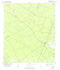
1978 Map of Townsend
USGS Topo · Published 1978About this map
Low-lying wetlands and timber-related transport corridors define this coastal Georgia landscape along the border of Long and McIntosh Counties. The community of Townsend serves as a local hub at the intersection of the Seaboard Coast Line railroad and several regional roads. A curious relic of military history, an Abandoned Bombing Target, remains visible in the western interior, surrounded by an intricate drainage network of canals and vast named wetlands including Big Mortar Swamp, Snuff Box Swamp, and Freecastle Swamp. The presence of the Warsaw Tram Road and numerous tracks through areas like Sandhill Bay suggests a history tied to the regional naval stores or logging industries. Smaller settlements such as Huxford, Warsaw, and Credit Hill are connected by rural routes like Briardam Road, which weave through the extensive swamp systems that dominate the topography.
Find a feature on this map
28 named features on this map. Tap any name to fly to it.
Don’t see what you’re looking for? This feature index may not catch every label — zoom into the map to look around manually.
Map Details
Editions of this 1978 Townsend Map
This is the sole edition of this map. No revisions or reprints were ever made.
Other maps of this area

1918 · Everett City
USGS Topo · 1:62,500

1920 · Sapelo River
USGS Topo · 1:62,500

1920 · Everett City
USGS Topo · 1:62,500

1921 · Darien
USGS Topo · 1:62,500

1943 · Ludowici
USGS Topo · 1:62,500

1943 · Sapelo River
USGS Topo · 1:62,500

1944 · Everett City
USGS Topo · 1:62,500

1945 · Sapelo River
USGS Topo · 1:62,500

1946 · Brunswick
USGS Topo · 1:250,000

1948 · Brunswick
USGS Topo · 1:250,000