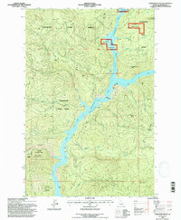
1994 Map of Township Butte
USGS Topo · Published 1997About this map
Dworshak Reservoir dominates this Clearwater County landscape, where the rising waters flooded the canyon of the Little North Fork Clearwater River. The map documents a period of transition within the Floodwood State Forest and St Joe National Forest, showing the road networks and water levels as they existed in the early 1990s. High points such as Township Butte and Armstrong Butte rise above the flooded timberlands, while the Grandad Br provides a critical crossing point over the reservoir's North Fork. Signs of earlier activity remain visible at the Camp X (Site) and the Homestead near Gleason Creek. These labels suggest a history of isolated habitation and forestry operations that preceded the reservoir's construction. The terrain is further defined by prominent landmarks like Tamarack Ridge and Boehls Butte, reflecting the remote and heavily timbered character of northern Idaho.
Find a feature on this map
46 named features on this map. Tap any name to fly to it.
Don’t see what you’re looking for? This feature index may not catch every label — zoom into the map to look around manually.
Map Details
Editions of this 1994 Township Butte Map
This is the sole edition of this map. No revisions or reprints were ever made.
Other maps of this area

1923 · Washington Creek
USGS Topo · 1:125,000

1936 · Boehls Butte
USGS Topo · 1:48,000

1938 · Headquarters
USGS Topo · 1:48,000

1943 · Boehls Butte
USGS Topo · 1:62,500

1944 · Headquarters
USGS Topo · 1:62,500

1955 · Pullman
USGS Topo · 1:250,000

1956 · Hamilton
USGS Topo · 1:250,000

1958 · Pullman
USGS Topo · 1:250,000

1959 · Hamilton
USGS Topo · 1:250,000

1960 · Hamilton
USGS Topo · 1:250,000