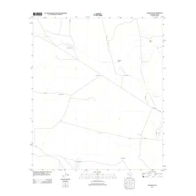
2013 Map of Toyah NW
USGS Topo · Published 2013About this map
Oil Well Windmill and CoCo Windmill stand as prominent landmarks in this arid section of Reeves County, where the landscape is defined by the vital search for water. The terrain is marked by ephemeral water sources and collection points such as Johnson Lake, Rock Tank, and Willis Tank. Several named springs, including Twin Spring, Johnson Spring, and Canyon Spring, offer a look at the natural hydrology that supported ranching in this West Texas region. The drainage of Cottonwood Cr and Coalson Draw cuts through the desert floor, leading toward the isolated height of Round Mtn in the northeast. The infrastructure of the early 21st century is represented by a network of county roads like Gresham Rd and Co Rd-231, which connect the various windmills that remain essential to the area's pastoral identity.
Find a feature on this map
24 named features on this map. Tap any name to fly to it.
Don’t see what you’re looking for? This feature index may not catch every label — zoom into the map to look around manually.
Map Details
Editions of this 2013 Toyah NW Map
This is the sole edition of this map. No revisions or reprints were ever made.
Other maps of this area

1921 · Toyah
USGS Topo · 1:125,000

1928 · Kent
USGS Topo · 1:125,000

1954 · Van Horn
USGS Topo · 1:250,000

1954 · Pecos
USGS Topo · 1:250,000

1957 · Pecos
USGS Topo · 1:250,000

1958 · Van Horn
USGS Topo · 1:250,000

1968 · W T Ranch
USGS Topo · 1:24,000
1968 · Halamicek Ranch
USGS Topo · 1:24,000

1970 · Big Hill
USGS Topo · 1:24,000

1970 · Toyah
USGS Topo · 1:24,000