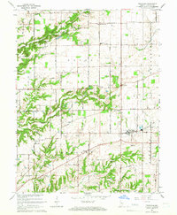
1965 Map of Trafalgar
USGS Topo · Published 1976About this map
Trafalgar serves as the primary hub of this Johnson County landscape, where the grain-growing plains of southern Indiana meet the more dissected drainage basins of Hensley Creek and Goose Creek. The mapping reveals a rural infrastructure deeply rooted in family and community, evidenced by numerous small burial grounds such as Shiloh Cem, Carmen Cem, and Simpson Cem. These sites, along with the Township Sch and Christian Chapel, mark the steady development of Union and Hensley townships.
Find a feature on this map
51 named features on this map. Tap any name to fly to it.
Don’t see what you’re looking for? This feature index may not catch every label — zoom into the map to look around manually.
Map Details
Editions of this 1965 Trafalgar Map
4 editions found
Other maps of this area

1942 · Franklin
USGS Topo · 1:125,000

1947 · Franklin
USGS Topo · 1:62,500

1948 · Franklin
USGS Topo · 1:24,000

1948 · Trafalgar
USGS Topo · 1:24,000

1948 · Nineveh
USGS Topo · 1:24,000

1948 · Fruitdale
USGS Topo · 1:24,000

1948 · Morgantown
USGS Topo · 1:24,000

1950 · Morgantown
USGS Topo · 1:24,000

1950 · Franklin
USGS Topo · 1:62,500

1952 · Bargersville
USGS Topo · 1:24,000