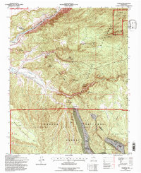
1995 Map of Trampas
USGS Topo · Published 1997About this map
The Sangre de Cristo Mountains dominate this 1990s landscape, where historical land grants and traditional New Mexican settlements converge. High in the Carson National Forest, the village of Trampas remains a focal point of the Las Trampas Grant, anchored by the Iglesia de Santo Tomas and the Escuela de Abajo. The terrain is deeply etched by water and human labor, from the Rio Grande and Embudo Creek to the community-managed Ditch La Plaza irrigation system near Dixon.
Find a feature on this map
47 named features on this map. Tap any name to fly to it.
Don’t see what you’re looking for? This feature index may not catch every label — zoom into the map to look around manually.
Map Details
Editions of this 1995 Trampas Map
This is the sole edition of this map. No revisions or reprints were ever made.
Other maps of this area

1953 · Truchas
USGS Topo · 1:24,000

1953 · Velarde
USGS Topo · 1:24,000

1953 · Trampas
USGS Topo · 1:24,000

1953 · Chimayo
USGS Topo · 1:24,000

1954 · Raton
USGS Topo · 1:250,000

1958 · Raton
USGS Topo · 1:250,000

1960 · Taos Junction
USGS Topo · 1:24,000

1961 · Carson
USGS Topo · 1:24,000

1964 · Penasco
USGS Topo · 1:24,000

1964 · Taos SW
USGS Topo · 1:24,000